
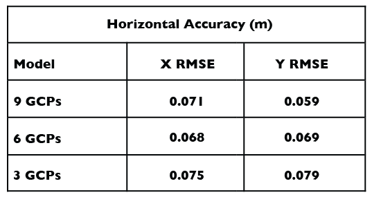
Horizontal (XY) RMSE
The aerial targets were measured in the orthomosaic and subtracted from the GCP coordinates to provide the horizontal offsets. Control points were dropped from the model to assess the strength of the
aerotriangulation (AT). The offsets were extremely close (2 cm) between models explaining that the AT was effective, even with less control.
Vertical (Z) RMSE
Z-values were extracted from the DTM by draping the 132 checkpoints to its surface (Figure 13). The vertical offsets of the DTM Z-values and the reference checkpoints provided the vertical root mean square error (RMSE). Similar methods were applied to a USGS LiDAR data set acquired in 2007.
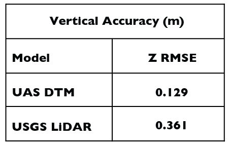
Interpretation of Vertical Offsets
Offsets with negative values (floating DTM Z- values) were predominantly clustered in the northern area, while positive offsets, by and large, were clustered in the southern area. Most of the northern area is covered by vegetation (Figure 14). Unlike LiDAR, correlated point clouds do not produce multiple returns. Therefore, the vegetation was recorded as ground explaining the offset phenomena. Note, however, that the DTM’s RMSE was still 20 cm lower than the LiDAR.

