MONTHLY ARCHIVES: MARCH 2014
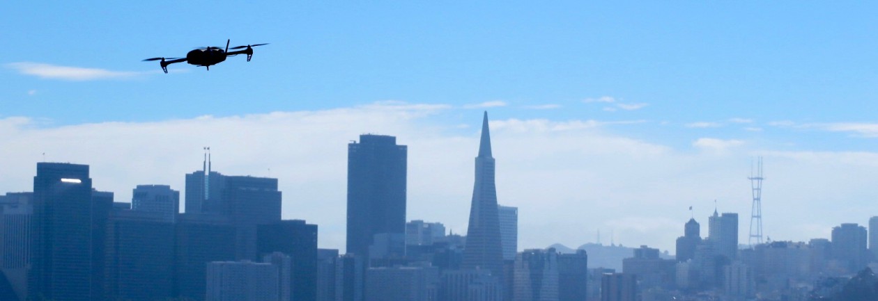
San Francisco Based Company “QuiQui” Offers Service for Delivering Drug Store Items Via Drones
 Drone delivery is already “taking off” in the city of San Francisco. QuiQui, an SF based start-up, is offering to deliver drug store items right to your door via a drone if you live in the city’s Mission District. The FAA’s recent loss in federal court is already opening up many opportunities for would be drone companies. It’s only a matter of time before Amazon Prime Air drones are delivering your next PS4 games.
Link courtesy of QuiQui: http://quiqui.me/
What is Photogrammetry?
What is Photogrammetry?

First aerial photo. Taken by Frenchman Felix Tournachon.
The first aerial photograph was taken from a balloon over Paris in 1858 [1]. Following the end of World War 1, many former military photographers turned aerial photography into a legitimate commercial business by developing their own aerial survey firms [1]. Since then, aerial photography has been an important utility for mapping and surveying professionals.
Lillesand et al. (2008) defines photogrammetry as “the science and technology of obtaining spatial measurements and other geometrically reliable derived products from photographs.” Many geometrically accurate products can be produced using photogrammetric techniques. Planimetric maps, digital terrain models (DTM), and raster imagery can be photogrammetrically produced in 2D or 3D and a used for geographic analysis in a GIS [2]. The ability to accurately measure and map large tracts of land make photogrammetry a viable alternative to expensive and time-consuming field surveys.
Based on Lillesand’s description, the following photogrammetric elements are key to any photogrammetry project:
- Image Scale: Based on flying height above ground and terrain elevation, the image scale can be used to make ground measurements relative to corresponding photo measurements.

Object Displacement: Unlike maps, aerial photographs do not show a true plan or top view of objects unless taken directly above the object. Object displacement causes objects, especially taller ones, to lean from their bases. Height measurements can be made, however, by factoring in the scale and amount of lean an object has. This practice is especially accurate when measuring an object or ground elevation in two overlapping images.

- Ground Control Points (GCP): GCPs are actual measurements made on the ground by a land survey crew. They are paramount to the geometric accuracy of any photogrammetry project.
- Flight Plan: Proper flight planning must take place to ensure the desired products can be produced in any photogrammetry project. Information about the camera, image scale, and photo overlap are all important factors in proper flight planning.
What is the Desired End Product?
Ortho-photographs (orthos) are generally the desired end product generated from photogrammetry. Orthos are generated by creating a mosaic of multiple photos together that are acquired with sufficient overlap (usually ≥ 60%) [1]. Areas outside the overlap are cropped out, leaving a mosaic of nadir images. A DTM is also applied to the mosaic, which geo-rectifies each image pixel. The ortho-rectified mosaic acts not only as an image without object displacement, but also as a geo-referenced map with accurate geographic location coordinates.
Breaking Down the Process of Generating Orthophotos
There are a number of software applications designed for generating orthos. For imagery acquired from a UAS, I have found great success using Agisoft’s Photoscan Pro. The interface is incredibly user-friendly, and there are plenty of tutorials available for support.
Aerotriangulation
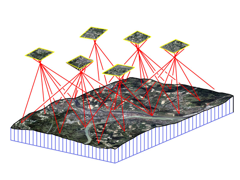
The initial step after acquisition is aerotriangulation (AT). AT is the method of orienting images to the proper geographic location (i.e., determining their position and rotations, in space). In photogrammetric jobs that only require one or two exposures, the GCPs are sufficient enough for image orientation. Jobs that require hundreds or thousands of images, however, would also require hundreds or thousands of GCPs, which would not be cost-effective. Therefore, AT bridges areas without ground control and reduces the number of ground control points needed. A pair of overlapping images can be relatively oriented to one another by measuring the exact same ground object (called a tie point) in each of the corresponding images. Photoscan automatically generates the tie points for the entire block of images during the “align photos” process. The GCPs complete the orientation of the block through methods of space resection, the process in which photocoordinates for at least four control points are measured to form a least squares solution for unknown points. Agisoft uses a bundle-adjustment to orient all of the images for a project. If GCPs are not available, GPS logs can be used for geo-referencing, albiet, with much less accuracy [1].
Auto-Correlated DTM
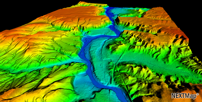
A reliable DTM is necessary for any orthophoto production. With an established AT solution, the software will be able to determine any point location on the ground, in relation to the images, by using collinearity equations. According to Lillesand et al., “Collinearity is the condition in which the exposure station of any photograph, any object point in the ground coordinate system, and its photographic image all lie on a straight line.” By automatically applying collinearity equations to identical points in multiple images, the software is able to triangulate the corresponding ground x, y, and z location using space intersection [1]. Photoscan has the capability of measuring millions of points automatically through this triangulation method. A dense 3D point cloud of measured points is the first derived product. Interpolating the points into a grid for the entire area will then generate the DTM.
Ortho-Mosaic

The final step is to generate the ortho-mosaic. Photoscan uses the AT solution and DTM to write ortho-rectified GeoTIFFs (i.e. TIFF images that have geographic information embedded into their metadata). The software applies collinearity equations to project each image pixel to its corresponding ground location on the DTM, eliminating much of the object displacement present in the raw images. Photoscan is unique in the sense that it mosaics (or stitches) all of the images together at the same time it rectifies them. The software uses an “adaptive-mosaic” method to compensate for intensity/color differences between adjacent/overlapping images during the mosaic procedure.
The other element of ortho generation is the resampling process. By resampling each raw image, using cubic convolution methods, the software creates an ortho that contain a uniform pixel size.
Robot Eyes Protecting From Above: Drones and Ocean Conservation
Link Courtesy of National Geographic: http://newswatch.nationalgeographic.com/2014/03/19/robot-eyes-protecting-from-above-drones-and-ocean-conservation/
 “Traditionally, one of the most important tools in monitoring and protection of the oceans is aerial surveillance. When used for our ocean, current approaches involve rental of flight time on private aircraft or the use of military aircraft as a secondary mission. Unfortunately, this method typically results in less desirable coverage or lower frequency of flights due to the high costs involved and pilot limitations.”
“Thankfully, there now exists a technology that can change this approach forever. The Unmanned Aerial Vehicle (commonly called a UAV, UAS, or drone) is a reusable robotic aircraft that can fly without a human pilot or crew on-board and, as a result, does not suffer the same issues associated with pilot fatigue or high operational costs.”
“Through the democratization and demilitarization of drone technology, there are a number of issues that can be solved more cheaply and effectively than our current methods.”
“Drone technology is in the midst of a technological boom. In the coming years, we will be seeing more and more uses for these platforms and acceptance into the industries that are ripe for this sort of innovation.”
iPhoneDrone Project – UAS Equipment
The sUAS market is blossoming at an exceptionally swift pace. Being that I did not have a hobbiest background before starting this project, I wanted to find a package that was easy to use and that I could operate right out of the box. Autonomous capabilities were a must, and most importantly, it needed to be reasonably affordable for a someone still in college.
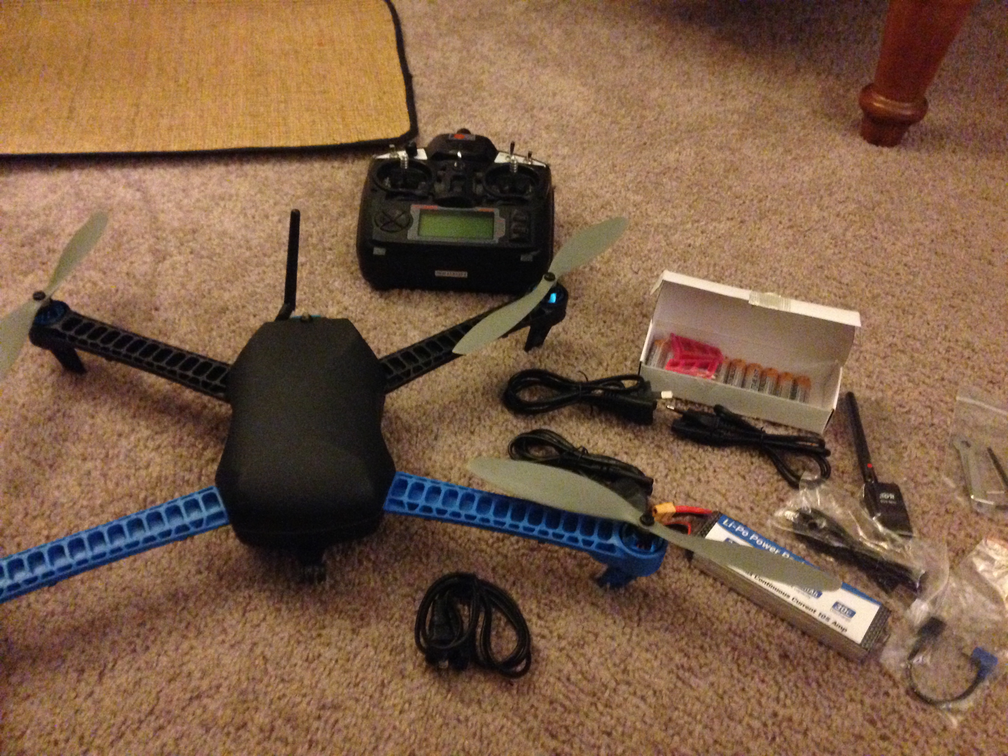
IRIS Package Includes: Copter, Battery and Charger, Tools, R/C, Accessories
After seeing a presentation by 3D Robotics last August, I was sold on their products based on their prices and track record. The IRIS is 3DR’s flagship product. The quadcopter comes with everything necessary, including a battery and R/C controller, in a convenient package. Technicians even pre-program the R/C with 5 different flight settings.

The other key component necessary was the camera and camera mount. I had an iPhone already, so the camera was taken care of. Configuring a mount though was a major challenge since nothing exists on the market for iPhones. Copters by nature produce high frequency vibrations and without the proper mount, the vibrations will bleed into your photos/video. This effect is commonly referred to as “jello.”
As I came to find out, the iPhone’s CMOS rolling shutter sensor is especially susceptible to jello. To fix this, I ordered a vibration dampening mount made for a DJI Phantom. To my surprise, the mounting screw locations matched the IRIS’ bottom vents perfectly! After finding some go pro mounts, extension legs, and clear iPhone case, I had pieced together a vibration free fixed iPhone 5s mount for the bottom of my IRIS (See gallery below).
Since installing the mount, the images from my iPhone are now about 90-95% jello free. More experiments are under way to improve image quality even more, but for now, I’m pretty satisfied with the results.


- Equipment 1

- IRIS W/Legs 1

- IRIS W/Legs 2

- Equipment 2

- iPhone 5s

- Case with Mount 1

- Case with Mount 2

- iPhone 5s installed backwards

- Camera installed 1

- Camera installed 2

- Camera installed 3

- Camera installed 4

- Camera installed 5

- Vibration free mount 1

- Vibration free mount 2

- Vibration free mount 3

- Vibration free mount 4

LANDMARK CASE: Federal Judge rules against FAA, dismisses commercial drone case. Drones are now Legal!! Wait… are they??

As hard as they try to regulate UAS, the FAA just cannot catch a break. The UAS world is buzzing right now afteryesterdays landmark court decision. If you have not heard by now, federal judge Patrick Geraghty of the NTSB ruled against the FAA by dismissing it’s case against Team Blacksheep’s “R/C Daredevil” Raphael Pirker. The Administration’s claim was that Mr. Pirker violated FAA regulation 91.13(a) by operating a UAS carelessly, recklessly, and for monetary gain. For punishment, Mr. Pirker was to pay a fine of $10,000.
In a nutshell, Mr. Geraghty’s ruling was based on the FAA’s lack of having a clear definition when distinguishing between “aircraft” (or UAS) and “model aircraft and ultralight vehicles.” As discussed previously, operators of model aircraft are allowed to fly for “recreation/sport” under the authority of AC 91-57 – basically at their own discretion as long as they follow a few simple guidelines. After yesterday though, the FAA essentially has no grounds to fine anyone operating a small UAS until clearer definitions are put forth regarding what is and what is not a UAS.
I wanted to shift gears away from the actual case for a minute and talk about the reaction/misinterpretation many folks are having already.”Commercial Drones Are Completely Legal, a Federal Judge Ruled” was the first article that immediately grabbed my attention to this subject. The title of this article should not be taken literal. Mr. Geraghty never specifies the legally of drones in his ruling; rather that the FAA has not defined them well.
The FAA’s credibility suffers the most from all of this. Pandora’s box has exploded, and UAS operators are now knowingly, or unknowingly, going to think it’s OK to operate commercially. Any future rulings made by the FAA will be laughed at even more than before. A peer of mine suggested the FAA will try to flex it’s muscles by shutting down all model aircraft. Others are optimistic that the Administration is now forced write rules immediately, an action the community as yearned for for years.
Whatever the eventual outcome may be, this decision will have a major impact on UAS legislation. I look forward to watching this legal soap opera unravel over the next few weeks and months.
0 Shades of Gray: FAA Seeks to Bust Myths Surrounding UAS
 Complimenting my post last week about the FAA and UAS regulations, the Administration published a list of regulation myths – and countered them with facts. The following were key points I picked up:
- “There are no shades of gray in FAA regulations.” Commercial operations are not allowed under any circumstances unless authorized (on a case-by-case basis) by the FAA. This applies even to operations on private property or under 400 ft. As I laid out, only certified pilots are allowed to operate UAS and must obtain either an airworthiness certificate (civil use) of COA (public use).
- There are no guarantees that commercial UAS will be allowed starting September, 2015. The FAA does it’s best to dance around the anticipated date by reiterating a “safe integration” plan is in the works for next year. Interpretation of this is subjective at best. What happens on 09/2015 when the FAA says, “we are not convinced that UAS can be safely integrated at this time?” The realist inside me judges the FAA on their previous record, and so far, there has been nothing but delays. I’m a firm believer that the FAA will use any negative occurrence/event to justify why UAS are not “safe” enough to be integrated to the national airspace.
- The FAA is still overtly out of touch with the UAS industry. Assuming that there will only be 7,500 small commercial UAS by 2018 is a gross underestimate. There are likely 10,000+ (legally or not) UAS operating NOW.
The full list of UAS myths and facts can be found here.
UAS Monitor Pollution in China
Courtesy: ECNS
“The high-definition cameras carried by the drones took pictures of every chimney discharging waste gas into the air. Pictures showed that some companies’ emission levels did not meet the national standards.”
