Tag Archives: mapping

What is Photogrammetry?

What is Photogrammetry?

First aerial photo. Taken by Frenchman Felix Tournachon.

The first aerial photograph was taken from a balloon over Paris in 1858 [1]. Following the end of World War 1, many former military photographers turned aerial photography into a legitimate commercial business by developing their own aerial survey firms [1]. Since then, aerial photography has been an important utility for mapping and surveying professionals.

Lillesand et al. (2008) defines photogrammetry as “the science and technology of obtaining spatial measurements and other geometrically reliable derived products from photographs.” Many geometrically accurate products can be produced using photogrammetric techniques. Planimetric maps, digital terrain models (DTM), and raster imagery can be photogrammetrically produced in 2D or 3D and a used for geographic analysis in a GIS [2]. The ability to accurately measure and map large tracts of land make photogrammetry a viable alternative to expensive and time-consuming field surveys.

Based on Lillesand’s description, the following photogrammetric elements are key to any photogrammetry project:

  • Image Scale: Based on flying height above ground and terrain elevation, the image scale can be used to make ground measurements relative to corresponding photo measurements.
  • Building lean is an example of object displacement
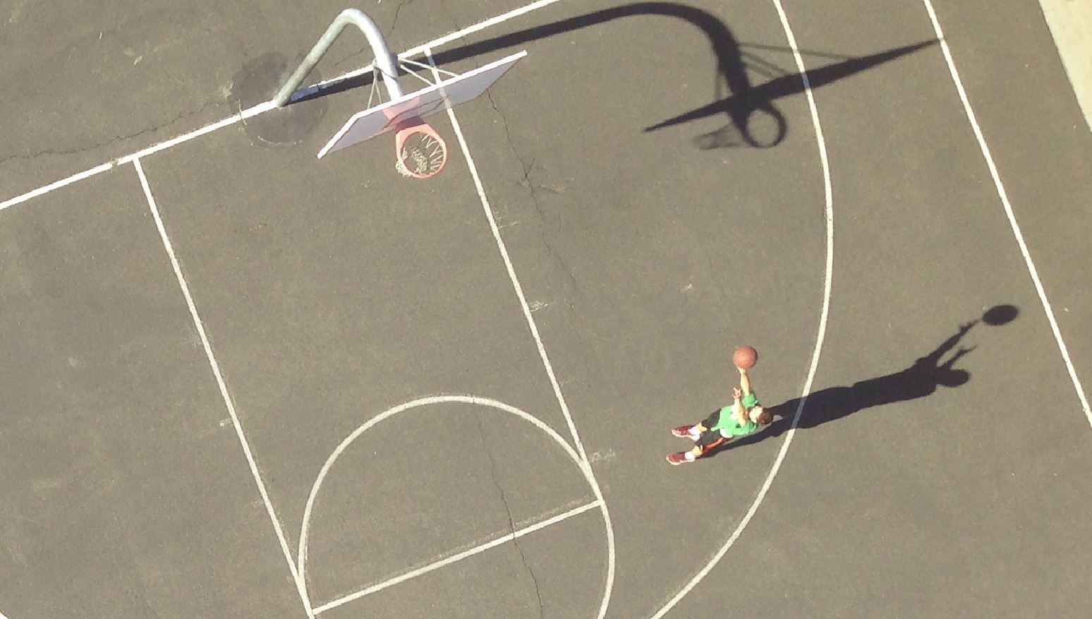
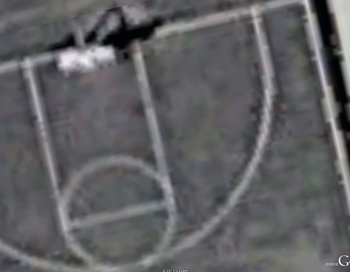
    Building lean is an example of object displacement

    Object Displacement: Unlike maps, aerial photographs do not show a true plan or top view of objects unless taken directly above the object. Object displacement causes objects, especially taller ones, to lean from their bases. Height measurements can be made, however, by factoring in the scale and amount of lean an object has. This practice is especially accurate when measuring an object or ground elevation in two overlapping images.

  • Ground Control Points (GCP): GCPs are actual measurements made on the ground by a land survey crew. They are paramount to the geometric accuracy of any photogrammetry project.
  • Flight Plan: Proper flight planning must take place to ensure the desired products can be produced in any photogrammetry project. Information about the camera, image scale, and photo overlap are all important factors in proper flight planning.

What is the Desired End Product?

Orthophotos are used in GIS as basemaps for heads-up digitizing, analysis, etc.

Ortho-photographs (orthos) are generally the desired end product generated from photogrammetry. Orthos are generated by creating a mosaic of multiple photos together that are acquired with sufficient overlap (usually ≥ 60%) [1]. Areas outside the overlap are cropped out, leaving a mosaic of nadir images. A DTM is also applied to the mosaic, which geo-rectifies each image pixel. The ortho-rectified mosaic acts not only as an image without object displacement, but also as a geo-referenced map with accurate geographic location coordinates.

Breaking Down the Process of Generating Orthophotos

There are a number of software applications designed for generating orthos. For imagery acquired from a UAS, I have found great success using Agisoft’s Photoscan Pro. The interface is incredibly user-friendly, and there are plenty of tutorials available for support.

Aerotriangulation

Image tie points and the relative orientations from the AT

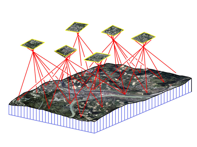
The initial step after acquisition is aerotriangulation (AT). AT is the method of orienting images to the proper geographic location (i.e., determining their position and rotations, in space). In photogrammetric jobs that only require one or two exposures, the GCPs are sufficient enough for image orientation. Jobs that require hundreds or thousands of images, however, would also require hundreds or thousands of GCPs, which would not be cost-effective. Therefore, AT bridges areas without ground control and reduces the number of ground control points needed. A pair of overlapping images can be relatively oriented to one another by measuring the exact same ground object (called a tie point) in each of the corresponding images. Photoscan automatically generates the tie points for the entire block of images during the “align photos” process. The GCPs complete the orientation of the block through methods of space resection, the process in which photocoordinates for at least four control points are measured to form a least squares solution for unknown points. Agisoft uses a bundle-adjustment to orient all of the images for a project. If GCPs are not available, GPS logs can be used for geo-referencing, albiet, with much less accuracy [1].

Auto-Correlated DTM

Digital Terrain Model

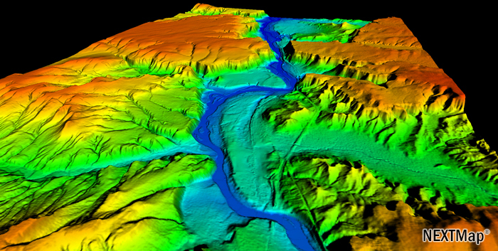
A reliable DTM is necessary for any orthophoto production. With an established AT solution, the software will be able to determine any point location on the ground, in relation to the images, by using collinearity equations. According to Lillesand et al., “Collinearity is the condition in which the exposure station of any photograph, any object point in the ground coordinate system, and its photographic image all lie on a straight line.” By automatically applying collinearity equations to identical points in multiple images, the software is able to triangulate the corresponding ground x, y, and z location using space intersection [1]. Photoscan has the capability of measuring millions of points automatically through this triangulation method. A dense 3D point cloud of measured points is the first derived product. Interpolating the points into a grid for the entire area will then generate the DTM.

Ortho-Mosaic

Mosaiced images of M&T Bank Stadium, Baltimore, MD.

The final step is to generate the ortho-mosaic. Photoscan uses the AT solution and DTM to write ortho-rectified GeoTIFFs (i.e. TIFF images that have geographic information embedded into their metadata). The software applies collinearity equations to project each image pixel to its corresponding ground location on the DTM, eliminating much of the object displacement present in the raw images. Photoscan is unique in the sense that it mosaics (or stitches) all of the images together at the same time it rectifies them. The software uses an “adaptive-mosaic” method to compensate for intensity/color differences between adjacent/overlapping images during the mosaic procedure.

The other element of ortho generation is the resampling process. By resampling each raw image, using cubic convolution methods, the software creates an ortho that contain a uniform pixel size.


1. Lillesand, T., Keifer, R., & Chipman, J. (2008). Remote Sensing and Image Interpretation (6th ed.). New Delhi, India. John Wiley & Sons, Inc.

2. McGlone, C., Mikhail, E., Bethel, J., & Mullen, R. (2004). Manual of photogrammetry (5th ed.). Bethesda, MD. American Society of Photogrammetry and Remote Sensing.

Robot Eyes Protecting From Above: Drones and Ocean Conservation

Link Courtesy of National Geographic: http://newswatch.nationalgeographic.com/2014/03/19/robot-eyes-protecting-from-above-drones-and-ocean-conservation/

SoarOcean-600x473“Traditionally, one of the most important tools in monitoring and protection of the oceans is aerial surveillance. When used for our ocean, current approaches involve rental of flight time on private aircraft or the use of military aircraft as a secondary mission. Unfortunately, this method typically results in less desirable coverage or lower frequency of flights due to the high costs involved and pilot limitations.”

“Thankfully, there now exists a technology that can change this approach forever. The Unmanned Aerial Vehicle (commonly called a UAV, UAS, or drone) is a reusable robotic aircraft that can fly without a human pilot or crew on-board and, as a result, does not suffer the same issues associated with pilot fatigue or high operational costs.”

“Through the democratization and demilitarization of drone technology, there are a number of issues that can be solved more cheaply and effectively than our current methods.”

“Drone technology is in the midst of a technological boom. In the coming years, we will be seeing more and more uses for these platforms and acceptance into the industries that are ripe for this sort of innovation.”

iPhoneDrone Project – UAS Equipment

The sUAS market is blossoming at an exceptionally swift pace. Being that I did not have a hobbiest background before starting this project, I wanted to find a package that was easy to use and that I could operate right out of the box. Autonomous capabilities were a must, and most importantly, it needed to be reasonably affordable for a someone still in college.

IMG_1558
IRIS Package Includes: Copter, Battery and Charger, Tools, R/C, Accessories

After seeing a presentation by 3D Robotics last August, I was sold on their products based on their prices and track record. The IRIS is 3DR’s flagship product. The quadcopter comes with everything necessary, including a battery and R/C controller, in a convenient package. Technicians even pre-program the R/C with 5 different flight settings.

Vibrations or "jello" cause distortions and smearing
Vibrations or “jello” cause distortions and smearing

The other key component necessary was the camera and camera mount. I had an iPhone already, so the camera was taken care of. Configuring a mount though was a major challenge since nothing exists on the market for iPhones. Copters by nature produce high frequency vibrations and without the proper mount, the vibrations will bleed into your photos/video. This effect is commonly referred to as “jello.”

As I came to find out, the iPhone’s CMOS rolling shutter sensor is especially susceptible to jello. To fix this, I ordered a vibration dampening mount made for a DJI Phantom. To my surprise, the mounting screw locations matched the IRIS’ bottom vents perfectly! After finding some go pro mounts, extension legs, and clear iPhone case, I had pieced together a vibration free fixed iPhone 5s mount for the bottom of my IRIS (See gallery below).

Since installing the mount, the images from my iPhone are now about 90-95% jello free. More experiments are under way to improve image quality even more, but for now, I’m pretty satisfied with the results.

UAS Applications

The burgeoning emergence of highly-capable consumer cameras combined with affordable and ready-to-fly (RTF) sUAS has empowered anyone with an interest to become an aerial photographer. The addition of youtube, geotagging, smartphones, and social networks has created a vast network of aerial video and imagery, available to anyone with an internet connection. Drone Analyst posted a great article about the Democratization of Aerial Photography highlighting this phenomenon.

Enabled by the democratization, the applications of UAS are endless. Those that receive the most attention are listed below:

  • High Resolution Aerial Survey and Mapping
1 cm resolution image acquired w/iphone and UAS
2.5 m? resolution taken from Google Earth

Being that I’ve been a photogrammetry and remote sensing professional for over 5 years, this area is of particular interest to me. The aerial survey industry has long relied on manned aircraft or satellites to acquire geospatial data. Professionals have a proven track record of manufacturing products with high levels of quality and accuracy. Three inch image resolution is the normal standard of high resolution imagery by most firms. Other sensors like LiDAR, synthetic aperture radar, and hyperspectural imagery are common acquisition platforms.

Small UAS have the potential to marginalize the current aerial survey and mapping industry. Their ability to fly low, cheap, and efficient could revolutionize the way geospatial data is collected in the next 2-5 years. Obtaining imagery with low-cost cameras/sensors at centimeter resolution is an absolute a reality at this time. What is lacking, however, is the proven quality and accuracy of these products compared to traditional industry counterparts.

  • Pipelines and Power Linespowerline_340

Utility companies are common clients for aerial survey firms. Corridor mapping is highly effective at collecting an inventory of utility infrastructure. SUAS are perfect for this application because of their ability to collect high-resolution imagery or LiDAR in only a few flight lines.

  • Precision Agriculture

ndvi farmndvi-vis-comparisonThere is a lot of buzz around using sUAS for vegetation analysis. This is achieved by acquiring imagery in the near-infrared (NIR) spectrum and then applying the normalized difference vegetation index (NDVI). Virtually any point-and-shoot can be converted to sense NIR (although quality is still unproven). The thinking around the UAS community is that agriculture will be the biggest market for NIR equipped sUAS. NDVI maps of ag fields would empower farmers to see exactly which fields are healthy and which are not. The Daily Beast wrote a great article about how drones could soon be ubiquitous to American farms.

  • Emergency Services

Search and rescue efforts throughout the world have already benefited from UAS. They are great detectors when equipped with thermal sensors. Unmanned aircraft have been used to detect and fight forest fires, and provide aid during flash floods. Whether used by public or private operators, UAS have already established their beneficial value when emergencies occur.

  • Journalism

One of the most obvious and controversial applications is journalism. It’s bad enough that the paparazzi apologetically harass celebrities on foot. Empowering them to shoot above someones private property is a whole different story. These journalism tactics strike the fear of “big brother” in many Americans.

There have been positive results to using drones for journalism, however. UAS have allowed film makers to obtain amazing aerial shots for movies, TV shows, and documentaries.   The makers of the “Flying-CAM Sarah” were recently honored by the Academy of Motion Pictures for it’s work in movies like “Skyfall,” “Oblivion,” and “Prisoners.”

  • Site Inspection

Rather than higher an expensive helicopter or manned aircraft, construction managers are increasingly turning to UAS technology. They are safer, cheaper, and provide all of the information from a bird’s-eye-view that a site manager would want to know. And they enable managers to easily monitor the progress of a site throughout the project’s life cycle.

quary demQuarry’s and landfills also benefit greatly from sUAS. 3D models can provide an accurate inventory of stockpiles and calculations of material volumes are easily attainable using sUAS acquired imagery.

  • Real Estate

Real estate is quickly becoming one of the most widely reported applications of UAS. “One 57,” Manhattan’s newest state-of-the-art condominium high-rise, used UAS as an incredibly effective marketing tool by capturing what views would look like on different floors. This enabled potential customers the opportunity to “see” what their view would be before the construction was even finished.

Some UAS operators are making legitimate profits by selling aerial videography services to real estate companies. Even though illegal, news stations from around the country are reporting on this as if it’s ok.

  • Delivery Service

1385949215000-AmazonPrimeAirOne of my favorite videos is from Domino’s in the U.K. of a drone delivering a pizza. The concept seemed far fetched initially, but in a matter months, there were videos of other companies jumping on the drone delivery bandwagon.

Amazon made the most publicized announcement when it aired a “60 Minutes” piece about future UAS delivery plans. Like many new ideas, there has been criticism and skepticism, but in the long run, I believe Amazon’s “Prime Air” will revolution parcel delivery.