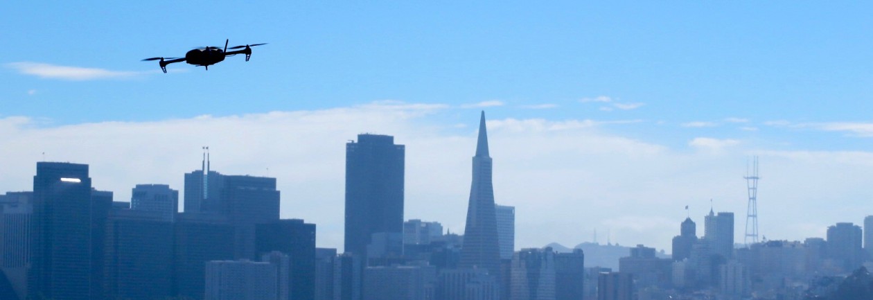
For the optimist, the news of additional funding for UAS integration ensures confidence that the United States is determined to open the skies, sooner rather than later, to commercial drone operations. News, however, that congress is “uncertain when the FAA can integrate UAS into the Nation’s airspace” enables skeptics to roll their eyes at yet another hollow justification of the delays by the government.
Truth be told, “the government is trying to have it’s cake and eat it too.” It’s fantastic that congress recognizes the importance of UAS integration into the Nation’s airspace. But admitting that the FAA may be incapable of fulfilling its duties is does not exactly conjure up positive feelings for those waiting on the sidelines.
Below is an excerpt from 2nd session of the 113th Congress:
The FAA Modernization and Reform Act of 2012 directed the FAA to integrate UAS into the National Airspace System by 2015. However, it is uncertain when the FAA can integrate UAS into the Nation’s airspace and what will be required to achieve the goal. The lack of an overall framework for the new systems may be inhibiting progress on UAS integration. The Committee is concerned that the FAA may not be well positioned to manage effectively the introduction of UAS in the United States, particularly in light of a recent ruling by a National Transportation Safety Board (NTSB) administrative judge regarding the use of a small UAS for commercial purposes. Given these challenges, the Committee has provided an additional $3,000,000 in the Aviation Safety Activity to expedite the integration of UAS into commercial airspace.
I know cliches aren’t exactly the most professional ways of making a point, but the best thing I could say to end this post is:
Dear FAA and Congress….. Actions speak louder than words.
A month ago, I posted about an innovative new approach to the design of fixed-wing drones. When I first saw the JUMP, by Arcturus, I was blown away at how such a simple idea could revolutionize the sUAS industry. By combining the vertical-take-off-and-landing (VTOL) capabilities of a multi-rotor with a fixed-wing platform, the failures associated with a conventional “crash-landing” are essentially eliminated.
Lo and behold, it only took a few weeks for me to start and seeing other hybrid systems already on the market. Birds Eye View Aerobotics’ FireFly6 stood out to me because of it’s simplistic design and economical price (about 800 bucks for everything). Check out the video to see how cool this drone is!
So is this new approach going to be adopted throughout the UAS industry? It will be interesting to check back in a year to gauge how many hybrid systems are out there. Considering the pace of progress, and the willingness of UAV manufactures to embrace new ideas, I would say absolutely.
The increasing potential of small UAS commercial applications continues to push the demand for rules and regulations to new heights. According to Aviation Week, the FAA is working to expedite COA exemptions for the agriculture, film making, pipeline/power-line inspection, and oil-and-gas inspection industries. For good reason, safety is touted as the number one reason that these industries are first in line for such exemptions. Jim Williams, the UAS integration office manager for the FAA, emphasized “exemptions will be for specific limited and low-risk operations.”
In true FAA fashion, however, Williams complicates matters by stating “there will still have to be a certified pilot with specific training for that type of aircraft. We can’t waive that.” So does this mean an individual with a certified pilot’s licence? If this is true, he is basically defining the requirements of the Special Airworthiness Certificate (SAC) which is already in place. In February, I challenged the FAA on the legitimacy of needing a certified pilot for sUAS operations. A justification was not given.
Maybe Williams is referring to a UAS specific pilot certification. Could it be that the FAA is taking the progressive approach of developing this certification in the very near future? This would be a breath of fresh air because it would help establish the beginning foundations of the regulation process.
I hate to sound like a pessimist, but my gut says that is wishful thinking.
Rohnert Park based Arcturus UAV has introduced an aircraft that combines the long-range benefits of a fixed wing airplane with the take-off and landing capabilities of a multi-rotor. JUMP seems like the perfect platform for those anxious over the “crash landing” technique associated with most fixed wing UAVs.
Yesterday, I posted an article about thermal camera mounted drones being used to locate illegal pot farms. This morning, I wanted to share yet another application of thermal/drone technology.
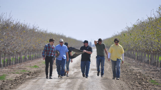
John Faus of HoneyComb demonstrates an agricultural drone in a pistachio orchard. (Photo courtesy Zach Sheely)
California is experiencing one of the worst droughts in history, and nobody is feeling it harder than the San Joaquin Valley (SJV) farmer. The SJV is the most agriculturally rich place in the world, and considering that it only makes up 4.5% of the total land mass of the United States, it’s remarkable to imagine that that it ranks first in production of 48 different different crops.
Nevertheless, farms need water, and every drop matters, especially during a drought of this magnitude. So when a group of farmers found their irrigation lines chewed up by coyotes, the need for an aerial survey became necessary. That’s when the company HoneyComb stepped in, providing thermal imagery from one of their drones. The thermal imagery provided the pinpoint locations of water leaks, making it incredibly more efficient to fix the problems and save water.
Zach Sheely, farmer, had this to say about the technology: “So if I can eliminate that job,” he says, “or use that person more wisely than just drive up and back mindlessly looking for leaks, it’s going to benefit my business, and he’s probably going to like his job a little bit better, too.”
“The investment in SUAS will enable us to inspect challenging or previously inaccessible locations, such as bridge crossings and wind farms, in an efficient and safe manner.” – Paul Casson, MACAW Principal Engineer
I wanted to pass along an exciting event hosted by the American Society of Photogrammetry and Remote Sensing (ASPRS) Northern California Region! The UAS Technical Demonstration and Symposium will take place October 21-22 in Reno, Nevada. An abstract of the event is below:
The ASPRS Northern California Region is hosting a 2-day symposium on unmanned aircraft systems (UAS) in Reno, NV on October 21-22, 2014. The purpose of the event is to assemble academia, UAS developers, survey and mapping companies, government agencies, and UAS enthusiasts, to share information, showcase new technologies and demonstrate UAS systems in action (in flight). The event will be held at the Reno Stead Airport, an FAA-designated UAS test site, as well as at a symposium hotel in downtown Reno. The mission of the event is to advance knowledge and improve the understanding of UAS technologies and their safe and efficient introduction into our national airspace, government programs and business.
Information about the symposium and ASPRS can be found attheir website, or you can contact me and I will point you in the right direction.
No matter the scale, flight planning has always been key to any successful aerial photogrammetry/remote sensing project. The rules for UAS are no different. Additionally, a successful flight plan is characterized by knowing the specifications of the camera/sensor and having a UAS that is capable of flying with that sensor mounted.
Part of the planning process involves defining a number of specifications for the desired end-product before going into the field. Some basic considerations include:
Image resolution: How much detail is desired? A smaller ground sample distance (GSD or pixel resolution) will have a higher resolution compared to a larger one. The flying height and focal length of a cameras sensor determine the pixel resolution.
Image overlap and sidelap: Image overlap and sidelap are essential for the establishment of tie points that orient the images and create the 3D model. Traditional standards call for 60% overlap and 30% sidelap, however, UAS acquisition usually requires higher variations of both.
Sun angle and weather: Reducing the amount of shadows is very important when capturing aerial imagery. Having the sun at it’s peak height in the sky minimizes shadows and allows the sensor to receive as much light as possible. Wind also plays an important factor. How powerful is your UAS? How powerful of wind gusts can in handle and still maintain a level position?
So you are ready to make a successful flight and have all of the flight planning figured out. The next question, however, is how geographically accurate should it be? If one is only interested in a product that is marginally accurate, say within 5-10 meters, than the GPS from the flight log file or camera would be sufficient.
For survey grade accuracy however, having a set of survey control points measured from a professional land surveyor is necessary. Control points are the most accurate way to ground truth any georeferenced product. Land surveying is expensive, however, so a product with an accuracy within 5-10 meters may be enough for some.
Software
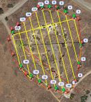
AOI in Red and Flight Lines in Yellow
For flight planning, I use Mission Planner, sponsored by 3D Robotics. It is free to download and very easy to use. I have an ideal ground station by combining this software and the supplied telemetry antennas that came with the 3DR IRIS. With a few simple clicks, Mission Planner is able to display flight data in real-time through a series of interchangeable gauges.
The Flight Plan tool allows the user to plan varies autonomous missions and tasks by establishing GPS waypoints. For my project, I used the survey (grid) tool. Within minutes I had my area of interest (AOI) polygon, entered my camera specifications (the iPhone 5s’ focal length is 4.12 mm) and set my overlap and sidelap (70 and 60 percent).
On top of flight planning, Mission Planner also acts as the control station for the IRIS. By using the supplied telemetry kit, my laptop was able to send and receive data in real-time to the copter. A log file was also recorded storing all of the flight parameters.
Imagery Acquisition
The desired pixel resolution for this project was 1 cm. Considering the highest resolution from traditional manned aircraft missions averages between
Image Courtesy of CameraSharp
1-3 inches, resolution to this degree from a consumer grade product like an iPhone is quite remarkable.
During the flight, the camera shutter was activated using an intervalometer feature from an app called CameraSharp. The app allows you to set the seconds interval at which you wish to snap photos. For this project, I went with one photo every second. I have yet to determine the exact amount of overlap I averaged, but considering the flying speed of the IRIS was well below the necessary limit for 70%, I’m guessing I achieved an overlap somewhere in the 75-80% range. I’ll post those results in a few months when my research is complete.
iPhone 5s and Flight Specs
The flying height was set at 28 m to obtain a pixel resolution slightly better than 1 cm at the sites lowest point. The figure to the right illustrates the iPhone 5s and flight specifications.
Ground Control
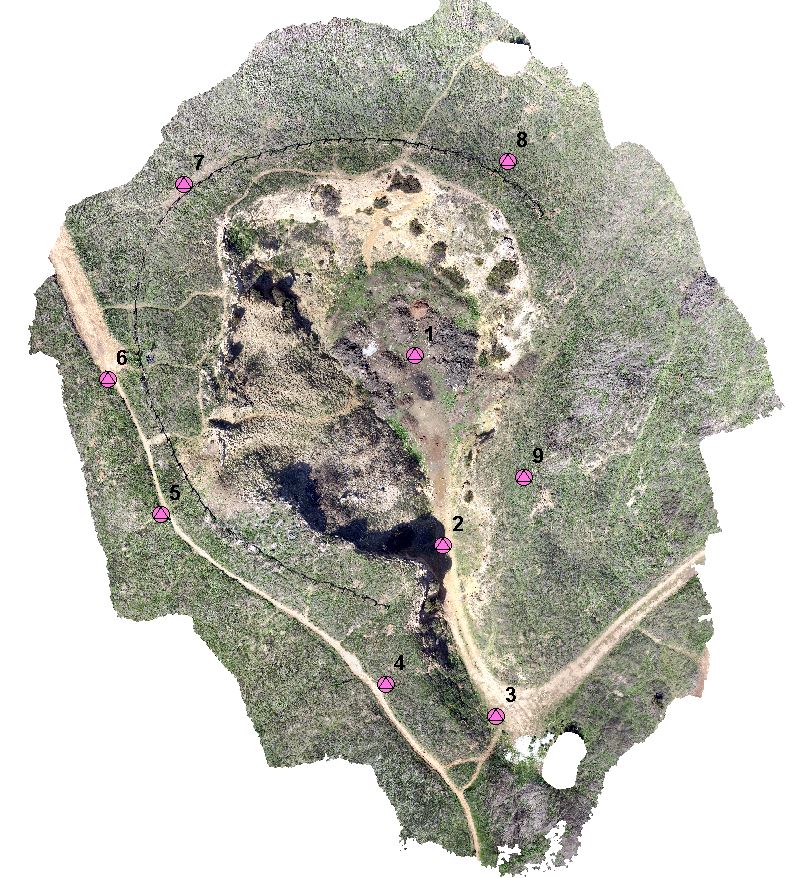
Having a professional land surveyor measure ground control points (GCPs) is the best way to accurately ground truth any geospatial data. Thankfully, I have some friends who had experience and equipment to measure GCPs for me at the Lime Ridge site. The control was measured using a Trimble real time kinematic (RTK) device. The RTK provides real-time corrections of GPS information by way of a network base station enabling the measurements to be accurate with 1 cm.
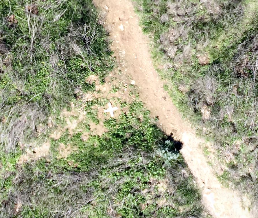
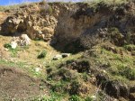
Aerial Target 5
Aerial targets were fabricated using some poster board that were cut 5 cm wide at the edges. Nine targets were placed around the site providing a sufficient ground truth throughout. The targets were measured during image processing.
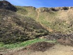
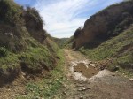
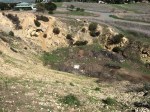
The site I chose for my project was an area of the Lime Ridge Open Space in Concord, CA. In the late 19th and early 20th centuries, limestone was mined in this area for cement production leaving behind a number of quarry ruins. Digging stopped in 1946, and in 1974, the land was purchased through a bond measure. It is 2nd largest open space in CA.
There are two large areas of the open space separated by Ygnacio Valley Rd. This project site is just north of Treat blvd. The terrain is perfect for showcasing topography while still being small enough to acquire imagery in one flight.
The burgeoning emergence of highly-capable consumer cameras combined with affordable and ready-to-fly (RTF) sUAS has empowered anyone with an interest to become an aerial photographer. The addition of youtube, geotagging, smartphones, and social networks has created a vast network of aerial video and imagery, available to anyone with an internet connection. Drone Analyst posted a great article about the Democratization of Aerial Photography highlighting this phenomenon.
Enabled by the democratization, the applications of UAS are endless. Those that receive the most attention are listed below:
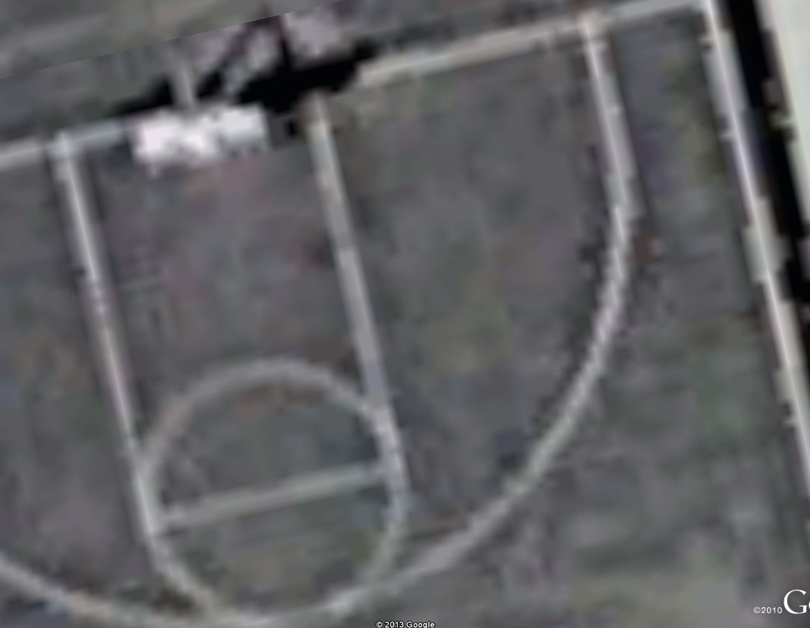
High Resolution Aerial Survey and Mapping
1 cm resolution image acquired w/iphone and UAS2.5 m? resolution taken from Google Earth
Being that I’ve been a photogrammetry and remote sensing professional for over 5 years, this area is of particular interest to me. The aerial survey industry has long relied on manned aircraft or satellites to acquire geospatial data. Professionals have a proven track record of manufacturing products with high levels of quality and accuracy. Three inch image resolution is the normal standard of high resolution imagery by most firms. Other sensors like LiDAR, synthetic aperture radar, and hyperspectural imagery are common acquisition platforms.
Small UAS have the potential to marginalize the current aerial survey and mapping industry. Their ability to fly low, cheap, and efficient could revolutionize the way geospatial data is collected in the next 2-5 years. Obtaining imagery with low-cost cameras/sensors at centimeter resolution is an absolute a reality at this time. What is lacking, however, is the proven quality and accuracy of these products compared to traditional industry counterparts.
Pipelines and Power Lines
Utility companies are common clients for aerial survey firms. Corridor mapping is highly effective at collecting an inventory of utility infrastructure. SUAS are perfect for this application because of their ability to collect high-resolution imagery or LiDAR in only a few flight lines.
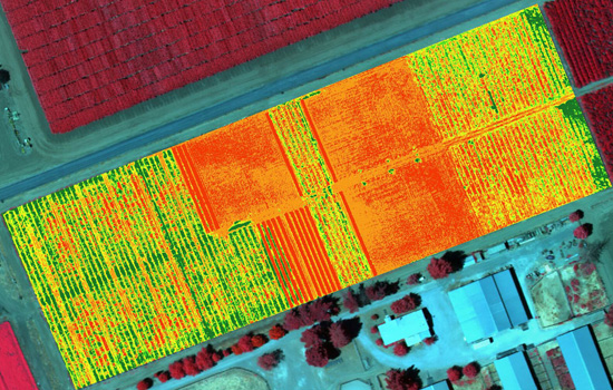
Precision Agriculture
There is a lot of buzz around using sUAS for vegetation analysis. This is achieved by acquiring imagery in the near-infrared (NIR) spectrum and then applying the normalized difference vegetation index (NDVI). Virtually any point-and-shoot can be converted to sense NIR (although quality is still unproven). The thinking around the UAS community is that agriculture will be the biggest market for NIR equipped sUAS. NDVI maps of ag fields would empower farmers to see exactly which fields are healthy and which are not. The Daily Beast wrote a great article about how drones could soon be ubiquitous to American farms.
One of the most obvious and controversial applications is journalism. It’s bad enough that the paparazzi apologetically harass celebrities on foot. Empowering them to shoot above someones private property is a whole different story. These journalism tactics strike the fear of “big brother” in many Americans.
There have been positive results to using drones for journalism, however. UAS have allowed film makers to obtain amazing aerial shots for movies, TV shows, and documentaries. The makers of the “Flying-CAM Sarah” were recently honored by the Academy of Motion Pictures for it’s work in movies like “Skyfall,” “Oblivion,” and “Prisoners.”
Site Inspection
Rather than higher an expensive helicopter or manned aircraft, construction managers are increasingly turning to UAS technology. They are safer, cheaper, and provide all of the information from a bird’s-eye-view that a site manager would want to know. And they enable managers to easily monitor the progress of a site throughout the project’s life cycle.
Quarry’s and landfills also benefit greatly from sUAS. 3D models can provide an accurate inventory of stockpiles and calculations of material volumes are easily attainable using sUAS acquired imagery.
Real Estate
Real estate is quickly becoming one of the most widely reported applications of UAS. “One 57,” Manhattan’s newest state-of-the-art condominium high-rise, used UAS as an incredibly effective marketing tool by capturing what views would look like on different floors. This enabled potential customers the opportunity to “see” what their view would be before the construction was even finished.
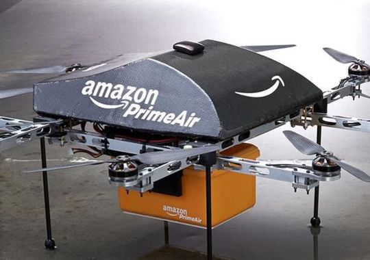
One of my favorite videos is from Domino’s in the U.K. of a drone delivering a pizza. The concept seemed far fetched initially, but in a matter months, there were videos of other companies jumping on the drone delivery bandwagon.
Amazon made the most publicized announcement when it aired a “60 Minutes” piece about future UAS delivery plans. Like many new ideas, there has been criticism and skepticism, but in the long run, I believe Amazon’s “Prime Air” will revolution parcel delivery.
Applied Photogrammetry Using Drone Technology and the World's Most Popular Camera